Cartagena de Indias · Bolívar, Colombia
Cartagena map: the old town, the city and the islands
This is the map of Cartagena de Indias, the city on the Caribbean coast of Colombia, not Cartagena in Spain. It comes at three scales. The old town: every place inside the walls and in Getsemaní is within 20 minutes on foot of the Clock Tower gate, so you walk it. The city: Bocagrande, the strip of beach towers, lies 2.2 km south of the gate in a straight line, the airport 4.4 km north-east, both a short taxi ride. The coast: Tierra Bomba lies across the bay, Playa Blanca on Barú 23 km away in a straight line (39 km by road) and the Rosario Islands farther out, all by boat, Barú also by road.
Some links on this page are affiliate links: the guide earns a commission when you book through them. The partner sets the price; the guide adds no fee.
1The map
Old town, city and coast, one map
Switch between the three scales, drag and zoom inside each, and turn the layers on and off. Every name is a link to the page that covers the place. The coral streets on the first two scales are the walk from the Clock Tower gate along the mapped streets at 4 km/h: darkest within 5 minutes, then 10 minutes and 20 minutes.
Drag to move. Pinch, use the buttons, or click the map and use the mouse wheel to zoom. With the map selected, the arrow keys move it and + and − zoom. Every name is a link.
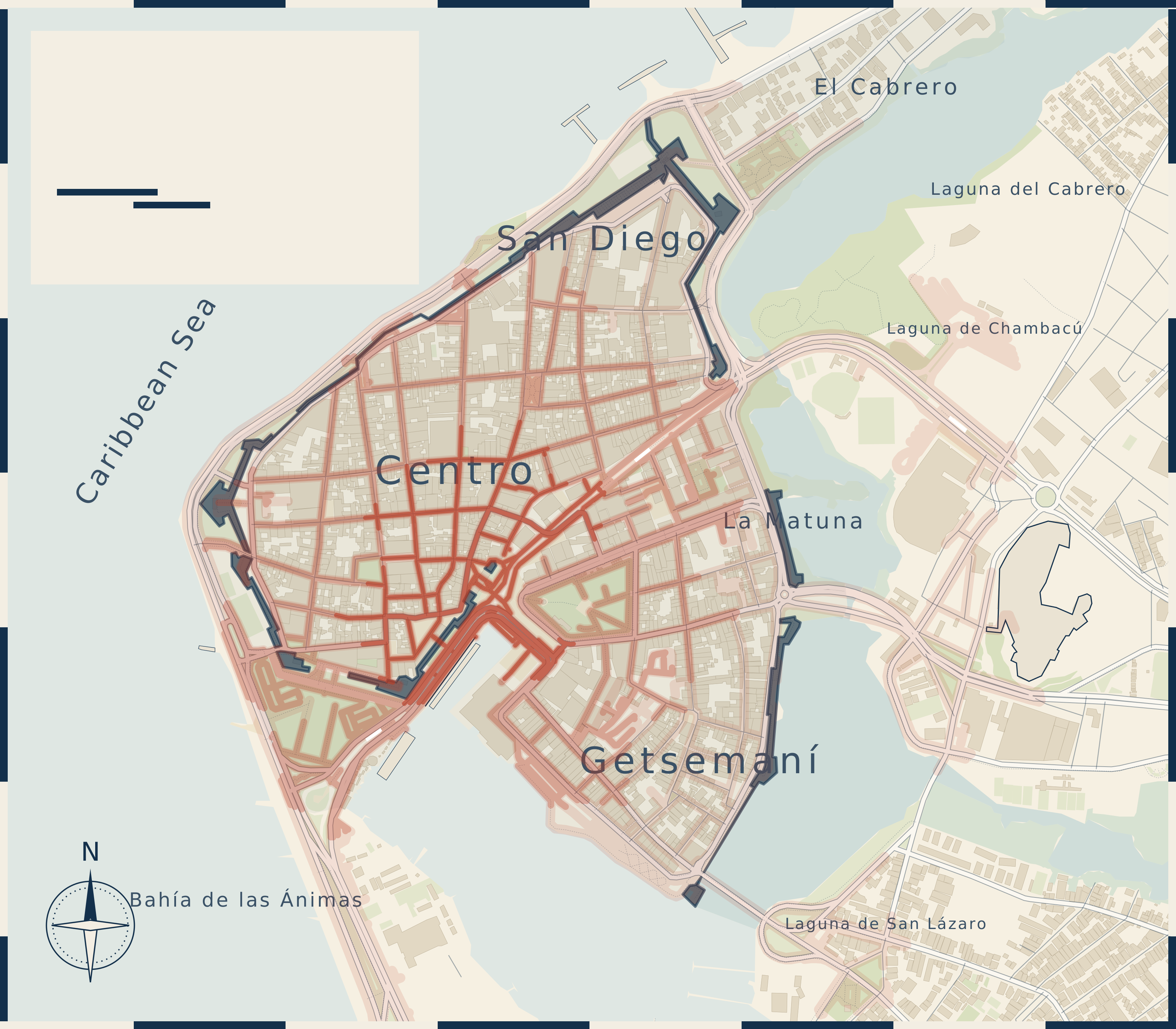
Map 1, index The old town and Getsemaní
- Clock Tower gate
- Plaza de los Coches
- Plaza de la Aduana
- Plaza de San Pedro Claver
- San Pedro Claver
- Naval Museum
- Plaza de Bolívar
- Palace of the Inquisition
- Gold Museum
- Cathedral
- Plaza Santo Domingo
- Santo Domingo church
- Baluarte de Santo Domingo
- Baluarte de San Francisco Javier
- Teatro Adolfo Mejía
- Plaza Fernández de Madrid
- Plaza de San Diego
- Las Bóvedas
- Baluarte de Santa Catalina
- Camellón de los Mártires
- Centenario Park
- India Catalina
- Convention Center
- Calle de la Sierpe
- Plaza de la Trinidad
- Trinidad church
- Calle San Juan
- Callejón Angosto
- Castillo San Felipe
- Zapatos Viejos
- Casa Museo Rafael Núñez
- Muelle de la Bodeguita
- Muelle de los Pegasos
- Transcaribe Centro
- Transcaribe La Bodeguita
- Transcaribe Chambacú
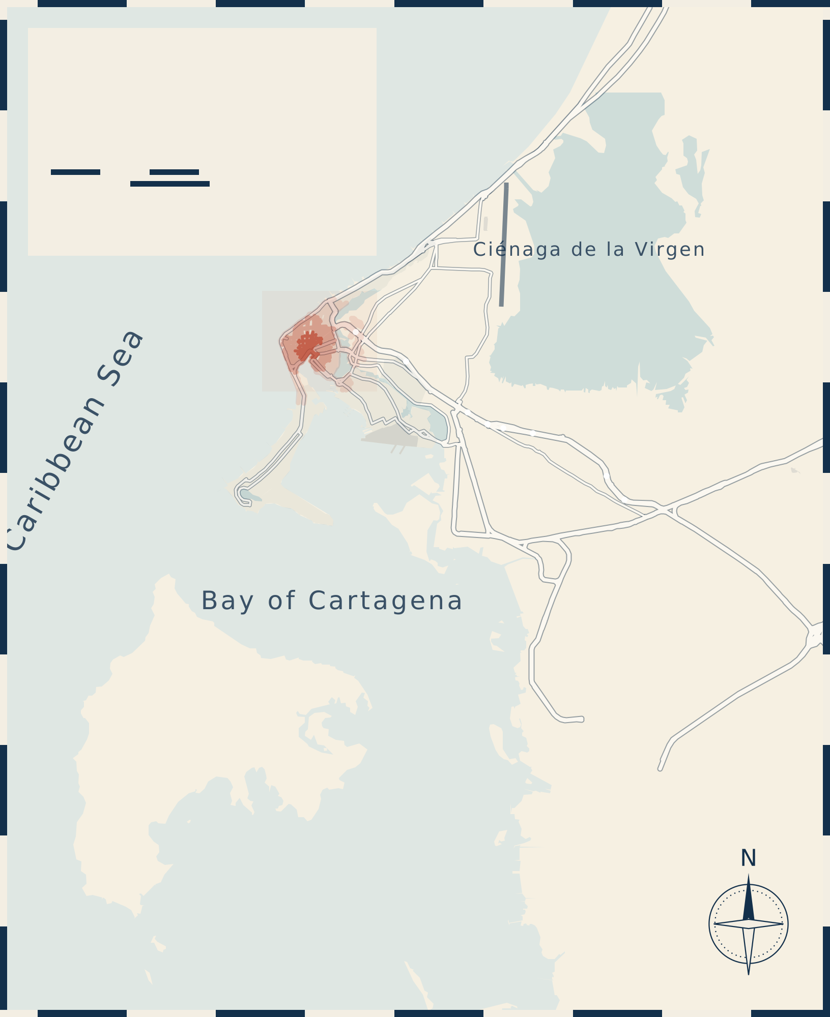
Map 2, index The city and the bay
- Airport (CTG) Transport
- Batería de San José Sight
- Bocachica Area
- Bocagrande Area
- Bocagrande beach Beach
- Bus terminal Transport
- Castillogrande Area
- Castillogrande beach Beach
- Crespo Area
- Cruise terminal Transport
- El Cabrero Area
- El Laguito Area
- El Laguito beach Beach
- Fuerte San Fernando Sight
- Getsemaní Area
- La Boquilla Area
- La Popa convent Sight
- Manga Area
- Mangroves, Ciénaga de la Virgen Sight
- Marbella Area
- Marbella beach Beach
- Old town Area
- Punta Arena Beach
- Tierra Bomba Area
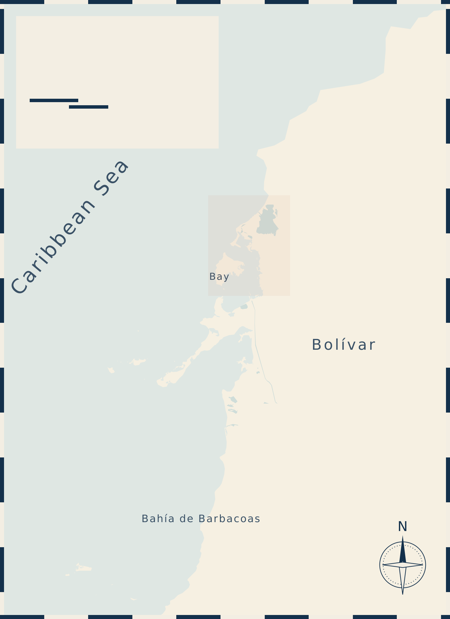
Map 3, index Islands and day trips
- Aviario Nacional Sight
- Barú Area
- Botanical garden, Turbaco Sight
- Cholón Beach
- Galerazamba Sight
- Isla del Pirata Area
- Isla Grande Area
- Múcura Island Area
- National park (sea) Area
- Oceanario Area
- Playa Blanca Beach
- Rosario Island Area
- Rosario Islands Area
- San Basilio de Palenque Sight
- San Bernardo Islands Area
- Santa Cruz del Islote Area
- Tintipán Island Area
- Totumo mud volcano Sight
2The lay of the city
How Cartagena is laid out
The walled city sits on a strip of land between the open Caribbean to the west and a chain of lagoons to the east. Its two quarters inside the walls are Centro, around the cathedral and Plaza de Bolívar, and San Diego to the north, with Las Bóvedas built into the northern wall. The main gate is the Clock Tower, the Torre del Reloj. Outside it, across Parque del Centenario, lies Getsemaní, the old barrio outside the main gate, and to the east of both, Castillo San Felipe stands on its hill 1.1 km from the gate.
South of the old town a narrow peninsula runs out into the sea: Bocagrande with its towers and city beach, then El Laguito at the tip and Castillogrande on the bay side. East of the walls, across the water, is Manga, an island of houses with the port and the cruise terminal on its far side. Behind it rises La Popa, the hill with the convent and the view over the city, 2.5 km from the gate.
North of the walls the beach road runs past Marbella and Crespo to the airport and on to La Boquilla, where the mangrove lagoon of the Ciénaga de la Virgen begins. To the south the bay opens behind Tierra Bomba, the island that closes it, with the forts of Bocachica on the narrow channel at the entrance to the bay. Beyond lie Barú, the Rosario Islands and, much farther, the San Bernardo Islands.
For walking to everything, sleep inside the walls or in Getsemaní; for the beach and high-rise hotels, Bocagrande; the trade-offs, area by area, are on where to stay in Cartagena.


Up the hillLa Popa is too far and too steep to walk in the heat. The guided tour with La Popa and San Felipe drives up and adds the fortress.
3On foot
Is Cartagena walkable?
The old town is. Inside the walls and in Getsemaní the farthest numbered place on the map, Baluarte de Santa Catalina, is 15 minutes from the Clock Tower gate along the streets at 4 km/h. The morning loop of the walled city covers its main squares in 3.1 km, about 47 minutes; the Getsemaní loop is 2.5 km, about 37 minutes. Castillo San Felipe is 1.3 km on foot, mostly along the avenue.
The rest of the city is walkable in distance but not in comfort. These are the walks from each area to the Clock Tower, measured along the mapped streets:
| Area | On foot | Minutes |
|---|---|---|
| Getsemaní | 680 m | 10 minutes |
| San Diego | 830 m | 12 minutes |
| La Matuna | 790 m | 12 minutes |
| El Cabrero | 1.4 km | 21 minutes |
| Manga | 2.3 km | 35 minutes |
| Bocagrande | 2.4 km | 37 minutes |
| Marbella | 2.9 km | 44 minutes |
| Castillogrande | 3.8 km | 57 minutes |
| El Laguito | 4.0 km | 60 minutes |
| Crespo | 4.9 km | 74 minutes |
| La Boquilla | 9.3 km | 140 minutes |
Heat decides the rest. The streets inside the walls are sheltered from the sea breeze, so the site's rule judges them by the felt temperature in still air. In February they stay cool enough to walk until about 9:45 in the morning and again from about 16:45 in the evening. Across the year the morning window ends as late as about 9:45 in January and as early as about 7:15 in May. Walk the old town early, spend the middle of the day indoors or on the water, and take a taxi or the bus for anything on the second map in the afternoon. The hour-by-hour figures are on Cartagena weather.
The Transcaribe buses run one trunk line through the old town, drawn as a dashed line on the first two maps, with stations at Centro, La Bodeguita and Chambacú; the fare is 3,900 COP. Route T102 ends in Crespo, near the airport, but the operator does not list the airport as a stop. Taxis and apps are on getting around Cartagena.
If you would rather walk the old town with someone who explains it, the shared walking tour of the historic center and Getsemaní takes 2.5 hours.


On the wallThe wall top is open to the breeze: the walk on the walls follows its own hours, best toward sunset.
4Ways in and out
Airport, cruise pier, bus terminal and boat docks
The airport, Rafael Núñez, sits in Crespo, 4.4 km north-east of the Clock Tower in a straight line. The airport operator gives about 10 minutes by road to the historic center. Fares to each area are on the airport page's fare map.
The cruise terminal is on the far side of Manga, 2.5 km from the gate in a straight line; the port operator gives 3.2 km to the walled city by road. The walk and the taxi from the gangway are on Cartagena cruise port.
The bus terminal for Barranquilla, Santa Marta and the rest of Colombia lies on the eastern edge of the city, 10 km from the gate in a straight line, at the right edge of the second map. Allow a long taxi ride across town to reach it.
The boats to the Rosario Islands, Barú and most beach clubs leave from Muelle de la Bodeguita, the pier south-west of the Clock Tower, 480 m away; sunset and bay boats use Muelle de los Pegasos beside it. Small boats to Tierra Bomba also leave from the bay beaches of Castillogrande and El Laguito; from Castillogrande beach to the landing of Tierra Bomba village, the Desembarcadero, is 2.3 km across the water in a straight line, and to the public beach at Punta Arena 3.3 km. Which dock for which island is on Cartagena islands.


5Gazetteer
Every place on the map
Each place on the three maps with its name in English and Spanish, what it is, and how far it is from the Clock Tower gate: in a straight line, and on foot along the streets where the walking network of the map reaches. Ask a taxi driver for the Spanish name.
| No. | Place | In Spanish | What it is | Straight line | On foot |
|---|---|---|---|---|---|
| Map 1: The old town and Getsemaní | |||||
| 1 | Clock Tower | Torre del Reloj | Main gate of the walled city; every distance on this page starts here | start | start |
| 2 | Plaza de los Coches | Plaza de los Coches | Square just inside the Clock Tower gate | 20 m | 10 m, 1 min |
| 33 | Los Pegasos Pier | Muelle de los Pegasos | Pier on the bay for sunset and bay boats | 110 m | 130 m, 2 min |
| 20 | Camellón de los Mártires | Camellón de los Mártires | Promenade between the Clock Tower and Parque del Centenario | 120 m | 130 m, 2 min |
| 3 | Plaza de la Aduana | Plaza de la Aduana | Square named for the colonial customs house | 180 m | 200 m, 3 min |
| 9 | Zenú Gold Museum | Museo del Oro Zenú | Gold museum of the Zenú culture, on Plaza de Bolívar | 180 m | 310 m, 5 min |
| 10 | Cathedral of Santa Catalina of Alexandria | Catedral de Santa Catalina de Alejandría | The cathedral of Cartagena | 180 m | 190 m, 3 min |
| 21 | Centenario Park | Parque del Centenario | Park between the walls and Getsemaní | 200 m | 490 m, 7 min |
| 4 | Plaza de San Pedro Claver | Plaza de San Pedro Claver | Square in front of the San Pedro Claver church | 230 m | 250 m, 4 min |
| 7 | Plaza de Bolívar | Plaza de Bolívar | Park with trees at the center of the walled city | 230 m | 340 m, 5 min |
| 5 | Sanctuary and Church of San Pedro Claver | Santuario e Iglesia de San Pedro Claver | Church and sanctuary of the Jesuit saint Peter Claver | 260 m | 310 m, 5 min |
| 8 | Palace of the Inquisition (Historical Museum of Cartagena) | Palacio de la Inquisición (Museo Histórico de Cartagena) | Palace of the Inquisition, now the city history museum | 260 m | 380 m, 6 min |
| 23 | Cartagena Convention Center | Centro de Convenciones Cartagena de Indias | Convention center on the bay side of Getsemaní | 280 m | 470 m, 7 min |
| 6 | Naval Museum of the Caribbean | Museo Naval del Caribe | Naval museum beside San Pedro Claver | 320 m | 430 m, 6 min |
| 11 | Plaza Santo Domingo | Plaza Santo Domingo | Square beside the Santo Domingo church, lined with café tables | 340 m | 420 m, 6 min |
| 12 | Church of Santo Domingo | Iglesia de Santo Domingo | Church of Santo Domingo | 370 m | 450 m, 7 min |
| 35 | Transcaribe La Bodeguita station | Estación La Bodeguita (Transcaribe) | Trunk-line station at the island pier, end of route T103 to Bocagrande | 370 m | 420 m, 6 min |
| 16 | Plaza Fernández de Madrid | Plaza Fernández de Madrid | Park square in San Diego | 390 m | 400 m, 6 min |
| 14 | Bulwark of San Francisco Javier | Baluarte de San Francisco Javier | Bastion at the south-west corner of the walls, where the wall walk starts | 410 m | 480 m, 7 min |
| 34 | Transcaribe Centro station | Estación Centro (Transcaribe) | Trunk-line station of the Transcaribe buses | 410 m | 440 m, 7 min |
| 24 | Calle de la Sierpe | Calle de la Sierpe | Residential street of Getsemaní on the morning walk | 420 m | 610 m, 9 min |
| 27 | Calle San Juan | Calle San Juan | Getsemaní street, Carrera 9 in the numbering | 440 m | 650 m, 10 min |
| 15 | Adolfo Mejía Theater (Teatro Heredia) | Teatro Adolfo Mejía (Teatro Heredia) | The city theater, also called Teatro Heredia | 450 m | 530 m, 8 min |
| 32 | La Bodeguita Pier | Muelle de la Bodeguita | The pier where most island boats leave | 480 m | 560 m, 8 min |
| 25 | Plaza de la Trinidad | Plaza de la Trinidad | The main square of Getsemaní and its evening | 500 m | 680 m, 10 min |
| 26 | Church of the Holy Trinity | Iglesia de la Santísima Trinidad | The yellow church on Plaza de la Trinidad | 510 m | 710 m, 11 min |
| 13 | Bulwark of Santo Domingo | Baluarte de Santo Domingo | Bastion on the sea wall, the old Café del Mar site | 550 m | 670 m, 10 min |
| 17 | Plaza de San Diego | Plaza de San Diego | The square at the center of San Diego | 590 m | 620 m, 9 min |
| 28 | Callejón Angosto | Callejón Angosto | Narrow pedestrian alley in Getsemaní | 600 m | 870 m, 13 min |
| 22 | India Catalina Monument | Monumento India Catalina | Bronze statue of India Catalina, east of the Clock Tower | 680 m | 720 m, 11 min |
| 18 | Las Bóvedas | Las Bóvedas | Vaults built into the north wall, now craft shops | 830 m | 1.0 km, 15 min |
| 19 | Bulwark of Santa Catalina | Baluarte de Santa Catalina | Bastion above Las Bóvedas, where the wall walk ends | 960 m | 1.0 km, 15 min |
| 36 | Transcaribe Chambacú station | Estación Chambacú (Transcaribe) | Trunk-line station near Castillo San Felipe | 1.0 km | 1.2 km, 18 min |
| 31 | Rafael Núñez House Museum | Casa Museo Rafael Núñez | House museum of the president Rafael Núñez in El Cabrero | 1.1 km | 1.3 km, 19 min |
| 29 | Castle of San Felipe de Barajas | Castillo San Felipe de Barajas | The Spanish fortress on San Lázaro hill | 1.1 km | 1.3 km, 20 min |
| 30 | Monument to the Old Shoes | Monumento a los Zapatos Viejos | Statue of a giant pair of old shoes behind the fortress | 1.3 km | 1.5 km, 22 min |
| Map 2: The city and the bay | |||||
| Historic Center (Walled City) | Centro Histórico | The walled city: Centro and San Diego | 210 m | 540 m, 8 min | |
| Getsemaní | Getsemaní | Barrio just outside the main gate, the evening quarter | 370 m | 680 m, 10 min | |
| El Cabrero | El Cabrero | Quarter north of the walls, by the lagoon | 1.2 km | 1.4 km, 21 min | |
| Marbella Beach | Playa de Marbella | Open-sea beach north of the walls | 1.7 km | ||
| Manga | Manga | Residential island quarter beside the cruise terminal | 2.0 km | ||
| Bocagrande Beach | Playa de Bocagrande | The long city beach along the hotel strip | 2.1 km | ||
| Bocagrande | Bocagrande | High-rise hotel strip on the peninsula, with the city beach | 2.2 km | ||
| Cruise Terminal (Sociedad Portuaria, Manga) | Terminal de Cruceros | Cruise ship berths at the port in Manga | 2.5 km | ||
| Convent of La Popa | Convento de la Popa | Convent on the hill above the city | 2.5 km | ||
| Marbella | Marbella | Quarter along the beach road north of the walls | 2.6 km | ||
| Castillogrande | Castillogrande | Quiet residential end of the peninsula, facing the bay | 3.2 km | ||
| El Laguito | El Laguito | Hotel tip of the Bocagrande peninsula | 3.3 km | ||
| El Laguito Beach | Playa El Laguito | Beach at the tip of the peninsula | 3.4 km | ||
| Castillogrande Beach | Playa de Castillogrande | Bay beach; boats to Tierra Bomba land here | 3.5 km | ||
| Crespo | Crespo | Quarter beside the airport | 4.2 km | ||
| Rafael Núñez International Airport | Aeropuerto Internacional Rafael Núñez | Rafael Núñez International Airport, in Crespo | 4.4 km | ||
| Punta Arena (Tierra Bomba) | Punta Arena | Public beach on Tierra Bomba | 6.4 km | ||
| Ciénaga de la Virgen / La Boquilla mangroves | Ciénaga de la Virgen / manglares de La Boquilla | Lagoon and mangrove channels behind La Boquilla | 6.7 km | ||
| La Boquilla | La Boquilla | Fishing village and beach north of the airport | 8.4 km | ||
| Tierra Bomba Island | Isla Tierra Bomba | Island across the bay, a short boat ride from the old town and the peninsula | 8.5 km | ||
| Cartagena Bus Terminal | Terminal de Transportes de Cartagena | Long-distance bus terminal on the eastern edge of the city | 10 km | ||
| Bocachica | Bocachica | Village on Tierra Bomba at the narrow bay entrance | 12 km | ||
| Fort San Fernando de Bocachica | Fuerte de San Fernando de Bocachica | Fort guarding the Bocachica channel | 12 km | ||
| San José Battery | Batería de San José | Battery across the channel from San Fernando | 13 km | ||
| Map 3: Islands and day trips | |||||
| Guillermo Piñeres Botanical Garden (Turbaco) | Jardín Botánico Guillermo Piñeres | Botanical garden in Turbaco, east of the city | 15 km | ||
| Playa Blanca (Barú) | Playa Blanca | The long white beach of Barú | 23 km | ||
| National Aviary of Colombia | Aviario Nacional de Colombia | Bird park on the road to Playa Blanca | 25 km | ||
| Cholón | Cholón | Shallow lagoon on Barú where party boats anchor | 32 km | ||
| Isla del Pirata | Isla del Pirata | Small hotel island in the Rosario group | 33 km | ||
| Isla Grande | Isla Grande | Largest of the Rosario Islands | 34 km | ||
| Rosario Islands (archipelago) | Islas del Rosario | Archipelago inside the national park, by boat | 35 km | ||
| Barú Island | Isla Barú | Island south of the bay, reached by bridge or boat | 35 km | ||
| San Martín de Pajarales Island (Oceanarium) | Isla San Martín de Pajarales (Oceanario) | Islet with the Oceanario aquarium | 37 km | ||
| Rosario Island | Isla Rosario | The island that gives the archipelago its name | 39 km | ||
| Totumo Mud Volcano | Volcán del Totumo | Mud volcano you climb and bathe in | 49 km | ||
| Galerazamba (Salinas / pink sea) | Galerazamba | Salt flats on the coast north-east of Cartagena | 51 km | ||
| San Basilio de Palenque | San Basilio de Palenque | Town founded by people who escaped slavery; its cultural space is on UNESCO’s list of intangible heritage | 52 km | ||
| Corales del Rosario and San Bernardo National Natural Park | Parque Nacional Natural Corales del Rosario y de San Bernardo | Marine national park around the Rosario and San Bernardo islands | 56 km | ||
| San Bernardo Archipelago | Archipiélago de San Bernardo | Far island group off the Gulf of Morrosquillo | 76 km | ||
| Tintipán Island | Isla Tintipán | Largest island of the San Bernardo group | 76 km | ||
| Santa Cruz del Islote | Santa Cruz del Islote | Tiny island village in the San Bernardo group | 79 km | ||
| Múcura Island | Isla Múcura | Island of the San Bernardo group | 80 km | ||
6Closer plans
The detailed drawings on other pages
This map shows where everything is. These drawings zoom in on one question each:
- The walled city with two walks: the morning loop through the squares and the sunset walk on the walls.
- Getsemaní by day and by night: the mural walk and the evening streets around Plaza de la Trinidad.
- Castillo San Felipe in section: the ramps, batteries and tunnels of the fortress.
- The area chooser: eleven places to sleep on one chart, with the walk to the gate.
- The beach scale: every beach from the hotel door to two hours by boat.
- The beach club chart: where the island clubs are.
- The Tierra Bomba crossing: four landings and where to leave from.
- The Barú plan: the road, Playa Blanca and the quieter beaches.
- The Rosario chart: the archipelago and the park boundary.
- The island picker: five island groups side by side.
- The day-trip ring map: every trip by distance from the Clock Tower.
- The airport fare map: the taxi fare to each area.
- The sunset line: where the sun sets on your date, seen from the walls.
7On paper
Print it or save it for offline
The old-town map prints on one page with its numbered index beside it. Use the button, or print the whole page from your browser, which puts the old-town sheet where the interactive map is.
To keep the map on your phone without a connection, save this page in your browser or open one of the drawings and save it: old town, city, region. They are plain image files and open in any browser. They do not show where you are; for turn-by-turn directions use the map app on your phone and look up the Spanish names from the gazetteer.
8Questions
Cartagena map questions
Is Cartagena, Colombia a walkable city?
The old town is. Every place inside the walls and in Getsemaní is within 20 minutes on foot of the Clock Tower gate. Bocagrande is 2.4 km away on foot and Manga 2.3 km, possible in the cool morning but hot by midday. For the airport, La Popa and the bus terminal, take a taxi or the Transcaribe bus.
What is the nicest area in Cartagena?
It depends on the trip. Inside the walls, Centro and San Diego put every sight within a short walk. Getsemaní, just outside the main gate, has about as many bars mapped as Centro. Bocagrande has the city beach and the high-rise hotels, 2.2 km from the gate in a straight line. Manga and Castillogrande are quieter and residential. The comparison is on where to stay in Cartagena.
How far is the airport from the old town of Cartagena?
Rafael Núñez airport is in Crespo, 4.4 km north-east of the Clock Tower in a straight line, along the beach road. The airport operator gives about 10 minutes by road to the historic center. A taxi is the usual way; Transcaribe route T102 ends in Crespo nearby, but the operator does not list the airport as a stop.
Is this Cartagena in Colombia or in Spain?
This is Cartagena de Indias in Colombia, on the Caribbean coast in the department of Bolívar. Cartagena in Spain is a port city in the region of Murcia, on the Mediterranean.
Can I use this map of Cartagena offline?
Yes. Print the old-town sheet with its numbered index, save this page in your browser, or save the three drawings, which are plain image files. They show the streets, sights, docks and distances but not your position. For live directions use a phone map app and the Spanish place names from the gazetteer.
Sources
- Rafael Núñez airport (CTG), Cartagena, Colombia: location and travel time to the historic centre and convention centre: 10 min. OINAC: Cómo llegar al aeropuerto.
- Cruise terminal of Cartagena, Colombia: distance to the Centro Histórico (walled city): 3.2 km. SPRC / Grupo Puerto de Cartagena: Terminal de Cruceros page (Wayback snapshot 2026-10-17).
- Road distance from the Clock Tower, Cartagena, Colombia to the end of the Vía a Playa Blanca at the south end of Playa Blanca (Barú), via Vía Mamonal, Pasacaballos and the bridge over the Canal del Dique, measured on OpenStreetMap road geometry: 39.4 km. OpenStreetMap road geometry (Overpass API, fetched 2026-11-11), shortest path measured with haversine segments, 2026-11-11.
- Map data for the streets, buildings, walls, coast, lagoons, islands, neighbourhood outlines and Transcaribe trunk lines on the full map of Cartagena, Colombia: licence: Open Database License (ODbL) 1.0, © OpenStreetMap contributors. OpenStreetMap Foundation: Copyright and License, 2026-11-12.
- Straight-line distance from Castillogrande beach (behind the Bocagrande hospital), Cartagena, Colombia to Punta Arena on Tierra Bomba: 3.3 km. Great-circle distance between 'playa-de-castillogrande' (OSM way 25446639) and the OSM node of Punta Arena (node 703210903), 2026-11-12.
- Straight-line distance from Castillogrande beach, Cartagena, Colombia to the landing beach of Tierra Bomba village (OSM 'Desembarcadero Tierra Bomba'): 2.3 km. Great-circle distance between 'playa-de-castillogrande' and OSM node 7390828759 'Desembarcadero Tierra Bomba', 2026-11-12.
- GetYourGuide listing 'Cartagena: Historic Center and Getsemaní Shared Walking Tour', Cartagena, Colombia: duration: 2.5 h. GetYourGuide product page t453794.
- Transcaribe (BRT) bus fare, Cartagena, Colombia: 3900 COP. Transcaribe S.A.: news 'Alcaldía de Cartagena expide decreto que fija nueva tarifa de Transcaribe', 2026-01-20.
- Transcaribe route T102 Portal - Crespo, Cartagena, Colombia: terminus: Crespo (the airport's neighbourhood); the airport is not named as a stop. Transcaribe S.A.: Rutas y recorridos Transcaribe SITM (route book PDF, modified 2024-07-03), 2024-07-03.
- Distances on the chart. Straight-line distance from the Clock Tower, computed from OpenStreetMap coordinates (ODbL).
- Felt temperature by month and hour. NOAA NCEI Integrated Surface Database, station 800220 (Rafael Nunez airport, Cartagena), hourly observations, 2016 to 2024; medians per month and hour (Steadman apparent temperature, shade).
Photographs
- City and Bocagrande skyline seen from La Popa hill. Photo: Bernard Gagnon, CC BY-SA 4.0, via Wikimedia Commons
- Brick walkway on top of the city walls, with the Caribbean on the left. Photo: Bernard Gagnon, CC BY-SA 4.0, via Wikimedia Commons
- Two cruise ships in the Bay of Cartagena, one docked at the port and one arriving. Photo: Joe Ross, CC BY-SA 2.0, via Wikimedia Commons